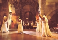
KAPADOKYA (TÜRKIYE)
Evil Eye (Nazar Bocuğu)
 A nazar or evil eye stone (Turkish: nazar boncuğu) is an amulet from ancient mythology that protects against the evil eye.
It consists of concentric circles (from inside out: dark blue, light blue (or yellow), white, dark blue). Therefore it is sometimes called "Blue Eye".
"In a shortened version we will try to explain. Once upon a time (yes, it starts like in a fairy tale) there was a rock by the sea that, even with the force of a hundred men and a lot of dynamite, couldn't be moved or cracked. There was also a man in this town by the sea, who was known to carry the evil eye (Nazar). After much effort and endeavor, the town people brought the man to the rock, and the man, upon looking at the rock said, "My! What a big rock this is." The instant he said this, there was a rip and roar and crack and instantly the immense and impossible rock was found to be cracked in two.
The force of the evil eye (or Nazar) is a widely accepted and feared random element in Turkish daily life. The word *Nazar* denotes seeing or looking and is often used in literally translated phrases such as "Nazar touched her," in reference to a young woman, for example, who mysteriously goes blind.
Another typical scenario. A woman gives birth to a healthy child with pink cheeks, all the neighbors come and see the baby. They shower the baby with compliments, commentating especially on how healthy and chubby the baby is. After getting so much attention weeks later the baby is found dead in his crib. No explanation can be found for the death. It is ascribed to Nazar. Compliments made to a specific body part can result in Nazar. That's why nearly every Turkish mother fixes with a safety pin a small Boncuk on the child's clothes. Once a Boncuk is found cracked, it means it has done his job and immediately a new one has to replace it. The people also often use the islamic word Masha'Allah which means 'God protect' in order to protect something or somebody from evil eyes.
from Wikipedia, the free encyclopedia
Links:
Anatalya (Antalya)
 History
In 150 BC Attalos II, king of Pergamon, founded the city of Attalia (present day Antalya) to base his powerful naval fleet. Later Antalya became part of the Roman Republic in 133 BC when King Attalos III of Pergamum willed his kingdom to Rome at his death and the city grew and prospered in the Ancient Roman period. Christianity started to spread in the region after 2nd century. Antalya was visited by Paul of Tarsus, as recorded in the Acts of the Apostles (Acts 14:25-26), (wherein Antalya is referred to as Attalia). St. Paul and St. Barnabas went to Antalya and sailed from there to Antioch after preaching in Pisidia and Pamphylia. The city later became a naval base for the Christian Crusades against the Muslims in the Levant and in Cyprus.
It was a major city in the Byzantine Empire. At the time of the ascension of John II Comnenus (1118) it was an isolated outpost against the Turks, accessible only by sea.[3]. The following year, with the aid of his commander-in-chief John Axuch, John II drove the Turks from the land routes to Antalya and recconected the city with the rest of the empire.
The city, along with the whole region, was conquered by the Seljuk Turks in the early 13th century. The Arabic traveler Ibn Battuta who came to the city in between 1335-1340 noted:
 “From Alaya I went to Antaliya [Adalia], a most beautiful city. It covers an immense area, and though of vast bulk is one of the most attractive towns to be seen anywhere, besides being exceedingly populous and well laid out. Each section of the inhabitants lives in a separate quarter. The Christian merchants live in a quarter of the town known as the Mina [the Port], and are surrounded by a wall, the gates of which are shut upon them from without at night and during the Friday service. The Greeks, who were its former inhabitants, live by themselves in another quarter, the Jews in another, and the king and his court and Mamluks in another, each of these quarters being walled off likewise. The rest of the Muslims live in the main city. Round the whole town and all the quarters mentioned there is another great wall. The town contains orchards and produces fine fruits, including an admirable kind of apricot, called by them Qamar ad-Din, which has a sweet almond in its kernel. This fruit is dried and exported to Egypt, where it is regarded as a great luxury.”
By the second half of the 17th century Evliya Çelebi recorded a city of narrow streets containing 3,000 houses in twenty Turkish neighbourhoods and four Greek. The town had grown beyond the city walls and the port could hold up to 200 boats.
In the 18th century, in common with most of Anatolia, its actual lord was a Dere Bey. The family of Tekke Oglu, domiciled near Perge, though reduced to submission in 1812 by Mahmud II, continued to be a rival power to the Ottoman governor till within the present generation, surviving by many years the fall of the other great Beys of Anatolia. The records of the Levant (Turkey) Company, which maintained an agency here till 1825, contain information as to the local Dere Beys.
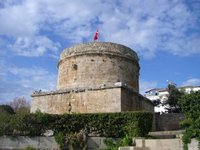
 In the 19th century the population of Antalya increased as Turks from the Caucasus and the Balkans moved into Anatolia. By 1911 it was a city of about 25,000 people, including many Christians and Jews, still living in separate quarters, round the walled mina or port. The port was served by coasting steamers of the local companies only. Antalya (then Adalia) was an extremely picturesque, but ill-built and backward place. The chief thing to see was the city wall, outside which runs a good and clean promenade and which survives to this day. The government offices and the houses of the better class were all outside the walls.
The city was briefly occupied by the Italians from the end of the First World War until the founding of the Turkish Republic in 1923.
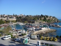
The city of Antalya is situated by the Gulf of Antalya on the Mediterranean coast. The Taurus mountain range of southern Anatolia runs parallel to the Mediterranean in an east-west direction, resulting in the formation of narrow coastal plains, which are surrounded by mountains on three sides and open south to the Mediterranean sea. On some parts of the coast, the mountains plunge sharply into the sea, forming small natural bays and peninsulas. Antalya is situated on a plain which consists of two flat areas formed of falez rock at a height of 35 m, where the mountains recede from the shore. On the first rocky plain on the coast is the town centre and on the plain behind it, named Kepezüstü, small settlement units have been established.
Etymology
In the 1st century BC, the Pergamum king Attalos II ordered his men to find "heaven on earth". After a long search all over the world, they discovered this land and said "This must be 'Heaven' " and King Attalos founded the city giving it the name "Attaleia" (Greek: Αττάλεια) which later became Adalia and then Antalya.
Climate
Since the area is closed to the cold northerly winds, it is characterized by the typical Mediterranean climate with hot, dry summers and moderately warm and rainy winters. Around 300 days of the year are sunny, the sea temperature never goes below 15°C and in summer is around 29°C. The temperature climbs up to 45°C in July and August. The sea breeze and the northeasterly winds blowing from inland relieve the area under this temperature.
 Economy
The economy of Antalya depends on a mixture of tourism, agriculture, and commerce, with some light industry. Agricultural production includes citrus fruits, cotton, cut flowers and even bananas. Antalya is a leading agriculture center of Turkey due to its suitable ecology. Antalya Metropolitan Municipality’s covered wholesale food market complex meets 65% of the fresh fruit and vegetable demand of Turkey.[6]
Industry
There is a military base in the city.
Tourism
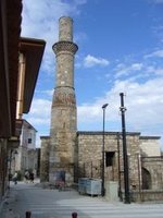
Places to visit in the city include sites with traces of Lycian,Pamphylian, Hellenistic, Roman, Byzantine, Seljuk and Ottoman architecture and cultures. Kaleiçi, with its narrow cobbled streets of historic Turkish and Greek houses is the old center of Antalya, now mainly hotels, gift shops, and bars. New hotels such as the Sheraton are along the coast above the Konyaalti and Lara beaches. The tourism boom has brought migrant labour to the city, fueled the growth of a large construction industry and provided transportation and other large-scale infrastructure which has led to Antalya becoming the hub of commerce in this part of Turkey. In summer tourists include Turkish, British, Israelis, Arabs Germans and Russians.
from Wikipedia, the free encyclopedia
Links:
www.antalya.gov.tr
www.aboutantalya.net
www.antalya-ws.com
Cappadocia (Kapadokya)
 Etymology
The earliest record of the name of Cappadocia dates from the late 6th century BC when it appears in the trilingual inscriptions of two early Achaemenid kings, Darius I and Xerxes, as one of the countries (Old Persian dahyu-) which are part of the Persian Empire. In these lists of countries the Old Persian name is Katpatuka, but it is clearly not a native Persian word. The Elamite and Akkadian language versions of the inscriptions contain a similar name from Akkadian katpa "side" (cf. Heb katef) and a chief or ancestor's name, Tuka.
Herodotus tells us that the name of the Cappadocians was applied to them by the Persians, while they were termed by the Greeks "Syrians" or "White Syrians" (Leucosyri). One of the Cappadocian tribes he mentions are the Moschoi, associated by Flavius Josephus with the biblical figure Meshech, son of Japheth, "and the Mosocheni were founded by Mosoch; now they are Cappadocians".
Cappadocia is also mentioned in the Biblical account given in the book of Acts 2:9, with the Cappadocians being named as one of the people groups hearing the Gospel account from Galileans in their own language on the day of Pentecost shortly after the resurrection of Jesus Christ. Acts 2:5 seems to suggest that the Cappadocians in this account were "God-fearing Jews". See Acts of the Apostles.
 Under the later kings of the Persian Empire they were divided into two satrapies, or governments, with one comprising the central and inland portion, to which the name of Cappadocia continued to be applied by Greek geographers, while the other was called Pontus. This division had already come about before the time of Xenophon. As after the fall of the Persian government the two provinces continued to be separate, the distinction was perpetuated, and the name Cappadocia came to be restricted to the inland province (sometimes called Great Cappadocia), which alone will be the focus of this article.
The kingdom of Cappadocia was still in existence in the time of Strabo as a nominally independent state. Cilicia was the name given to the district in which Caesarea, the capital of the whole country, was situated. The only two cities of Cappadocia considered by Strabo to deserve that appellation were Caesarea (originally known as Mazaca) and Tyana, not far from the foot of the Taurus.
History
Cappadocia was known as Hatti in the late Bronze Age, and was the homeland of the Hittite power centred at Hattusa. After the fall of the Hittite Empire, with the decline of the Syro-Cappadocians (Mushki) after their defeat by the Lydian king Croesus in the 6th century, Cappadocia was left in the power of a sort of feudal aristocracy, dwelling in strong castles and keeping the peasants in a servile condition, which later made them apt for foreign slavery. It was included in the third Persian satrapy in the division established by Darius, but long continued to be governed by rulers of its own, none apparently supreme over the whole country and all more or less tributary to the Great King.
 After bringing the Persian Empire to an end, Alexander the Great met with great resistance in Cappadocia. He tried to rule the area through one of his commanders named Sabictus, but the ruling classes and people resisted and declared Ariarathes, a Persian aristocrat, as king. This sent a message to Alexander that not all Persians would submit to his rule. Ariarthes I (332 - 322 BC) was a successful ruler, and extended the borders of the Cappadocian Kingdom as far as the Black Sea. The kingdom of Cappadocia lived in peace until the death of Alexander, when the kingdom fell, in the general partition of the empire, to Eumenes. His claims were made good in 322 BC by the regent Perdiccas, who crucified Ariarathes; but in the dissensions which brought about Eumenes's death, the son of Ariarathes recovered his inheritance and left it to a line of successors, who mostly bore the name of the founder of the dynasty.
Under Ariarathes IV, Cappadocia came into relations with Rome, first as a foe espousing the cause of Antiochus the Great, then as an ally against Perseus of Macedon. The kings henceforward threw in their lot with the Republic as against the Seleucids, to whom they had been from time to time tributary. Ariarathes V marched with the Roman proconsul Publius Licinius Crassus Dives Mucianus against Aristonicus, a claimant to the throne of Pergamon, and their forces were annihilated (130 BC). The imbroglio which followed his death ultimately led to interference by the rising power of Pontus and the intrigues and wars which ended in the failure of the dynasty.
The Cappadocians, supported by Rome against Mithridates VI of Pontus, elected a native lord, Ariobarzanes, to succeed (93 BC); but in the same year Armenian troops under Tigranes the Great (Tigran) entered Cappadocia, dethroned king Ariobarzanes and crowned Gordios as the new client-king of Cappadocia, thus creating a buffer zone against the encroaching Romans. It was not until Rome had deposed the Pontic and Armenian kings that the rule of Ariobarzanes was established (63 BC). In the civil wars Cappadocia was now for Pompey, now for Caesar, now for Antony, now against him. The Ariobarzanes dynasty came to an end and a certain Archelaus reigned in its stead, by favour first of Antony and then of Octavian, and maintained tributary independence until AD 17, when the emperor Tiberius, on Archelaus' death in disgrace, reduced Cappadocia at last to a Roman province. Much later it was a region of the Byzantine Empire.
 Cappadocia contains several underground cities (see Kaymaklı Underground City), largely used by early Christians as hiding places before they became a legitimate religion. The Cappadocian Fathers of the 4th century were integral to much of early Christian philosophy. It also produced, among other people, another Patriarch of Constantinople, John of Cappadocia, who held office 517–520. For most of the Byzantine era it remained relatively undisturbed by the conflicts in the area, first with the Sassanid Empire and later against the Islamic expansion led by Arabs.
Cappadocia shared an always changing relation with the neighbouring Armenia, by that time a region of the Empire. The Arab historian Abu Al Faraj purports the following about Armenian settlers in Sivas, during the 10th century: "Sivas, in Cappadocia, was dominated by the Armenians and their numbers became so many that they became vital members of the imperial armies. These Armenians were used as watch-posts in strong fortresses, taken from the Arabs. They distinguished themselves as experienced infantry soldiers in the imperial army and were constantly fighting with outstanding courage and success by the side of the Romans in other words Byzantine". As a result of the Byzantine military campaigns, the Armenians spread into Cappadocia and eastward from Cilicia into the mountainous areas of northern Syria and Mesopotamia. This immigration was increased further after the decline of the local imperial power and the establishment of the Crusader States following the 4th Crusade. Cappadocia became part of the Armenian Kingdom of Cilicia, a state formed in the 12th century by Armenian refugees fleeing the Seljuk invasion of Armenia and a close ally of the Crusaders.
 Following the Battle of Manzikert in 1071, various Turkish clans under the leadership of the Seljuks began settling in Anatolia. With the rise of Turkish power in Anatolia, Cappadocia slowly became tributary to the Turkish states that were established to the east and to the west, and some of the population converted to Islam. By the end of the early 12th century, Anatolian Seljuks had established their sole dominance over the region. With the decline and the fall of the Konya-based Seljuks in the second half of the 13th century, they were gradually replaced by the Karaman-based Beylik of Karamanoğlu, who themselves were gradually succeeded by the Ottoman Empire over the course of the 15th century. Cappadocia remained part of the Ottoman Empire for the centuries to come, and remains now part of the modern state of Turkey. A fundamental change occurred in between when a new urban center, Nevşehir, was founded in the early 18th century by a grand vizier who was a native of the locality (Nevşehirli Damat İbrahim Pasha), to serve as regional capital, a role the city continues to assume to this day.
In the meantime many former Cappadocians had shifted to a Turkish dialect (written in Greek alphabet, Karamanlıca), and where the Greek language was maintained (Sille, villages near Kayseri, Pharasa town and other nearby villages), it became heavily influenced by the surrounding Turkish. This dialect of Greek is known as Cappadocian Greek. Following the 1923 population exchange between Greece and Turkey, the language is now only spoken by a handful of the former population's descendants in modern Greece.
 Modern tourism
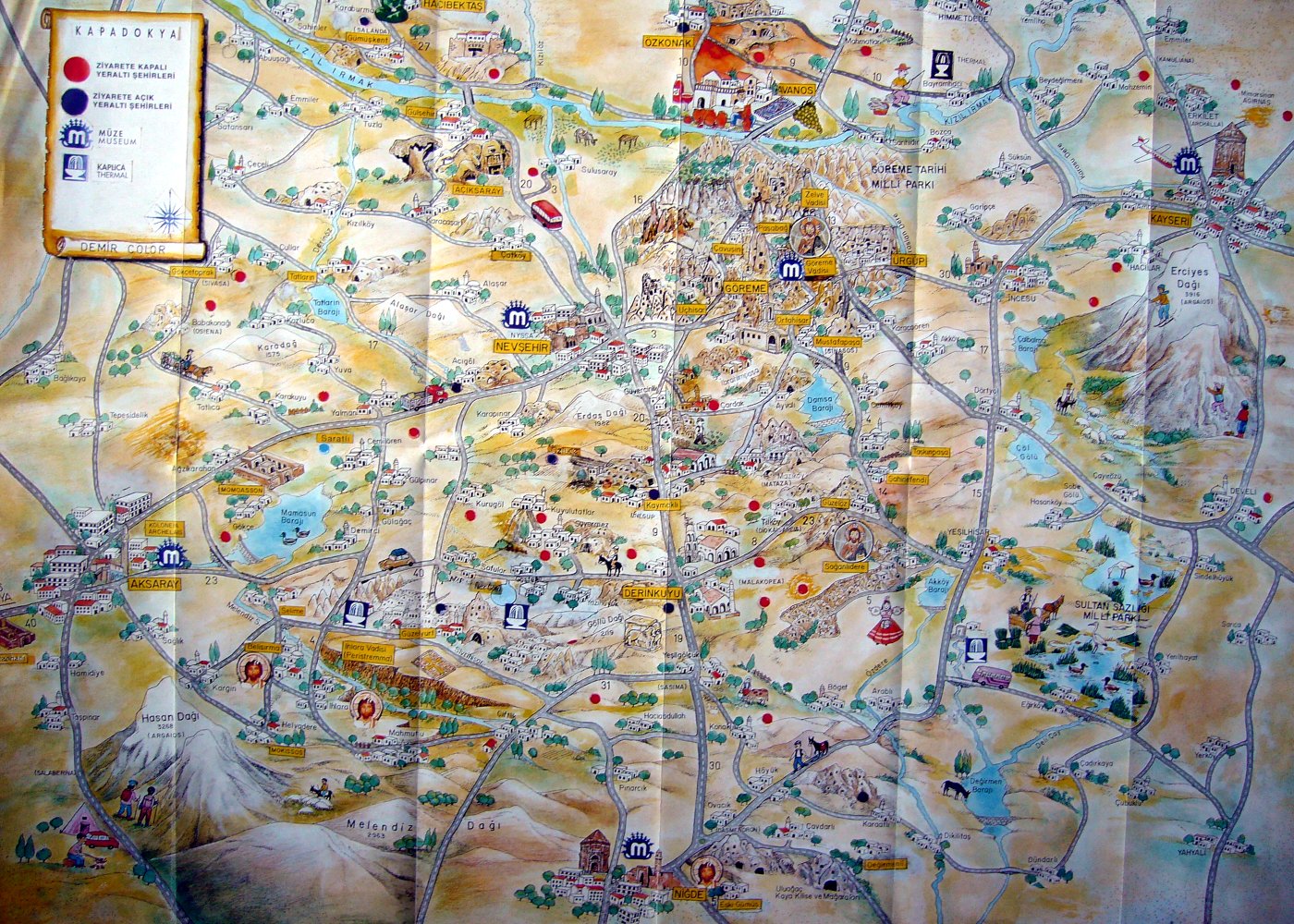
The area is a famous and popular tourist destination, as it has many areas with unique geological, historic and cultural features.
The region is southwest of the major city Kayseri, which has airline and railroad service to Ankara and Istanbul.
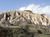
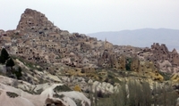
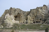
The Cappadocia region is largely underlain by sedimentary rocks formed in lakes and streams, and ignimbrite deposits erupted from ancient volcanoes approximately 9 to 3 million years ago (late Miocene to Pliocene epochs). The rocks of Cappadocia near Göreme eroded into hundreds of spectacular pillars and minaret-like forms. The volcanic deposits are soft rocks that the people of the villages at the heart of the Cappadocia Region carved out to form houses, churches, monasteries. Göreme became a monastic center between 300-1200 AD. First period settlement in Göreme reaches to the Roman period from Christianity. Yusuf Koç, Ortahane, Durmus Kadir and Bezirhane churches in Göreme, houses and churches carved into rocks till to Uzundere, Bağıldere and Zemi Valley carries the mystical side of history today. The Göreme Open Air Museum is the most visited site of the monastic communities in Cappadocia and is one of the most famous sites in central Turkey. It is a complex comprising more than 30 rock-carved churches and chapels containing some superb frescoes, dating from the 9th to the 11th centuries.
from Wikipedia, the free encyclopedia
Links:
www.cappadociaturkey.net
www.cappadociaonline.com